 Banaba (formerly Ocean Island) | |
| Geography | |
|---|---|
| Location | South Pacific Ocean |
| Coordinates | 0°51′34″S 169°32′13″E / 0.85944°S 169.53694°E |
| Area | 6.29 km2 (2.43 sq mi) |
| Highest elevation | 81 m (266 ft) |
| Administration | |
Kiribati | |
| Island council | Banaba |
| Demographics | |
| Population | 330[1] (2020) |
| Pop. density | 52.5/km2 (136/sq mi) |
| Languages | Gilbertese |
| Ethnic groups | Banabans (100%) |
| Additional information | |
| Time zone | |
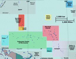
Banaba[notes 1] (/bəˈnɑːbə/; formerly Ocean Island) is an island of Kiribati in the Pacific Ocean. A solitary raised coral island west of the Gilbert Island Chain, it is the westernmost point of Kiribati, lying 185 miles (298 km) east of Nauru, which is also its nearest neighbour. It has an area of six square kilometres (2.3 sq mi),[2] and the highest point on the island is also the highest point in Kiribati, at 81 metres (266 ft) in height.[3] Along with Nauru and Makatea (French Polynesia), it is one of the important elevated phosphate-rich islands of the Pacific.[4]
- ^ "2020 Kiribati Population and Housing Census". Archived from the original on 10 October 2021. Retrieved 27 January 2021.
- ^ Dahl, Arthur (12 July 1988). "Islands of Kiribati". Island Directory. UN System-Wide Earthwatch Web Site. Archived from the original on 11 February 2012. Retrieved 14 April 2012.
- ^ "19. Banaba" (PDF). Office of Te Beretitenti – Republic of Kiribati Island Report Series. 2012. Archived from the original (PDF) on 23 September 2015. Retrieved 28 April 2015.
- ^ C.Michael Hogan. 2011. Phosphate. Encyclopedia of Earth. Topic ed. Andy Jorgensen. Ed.-in-Chief C.J.Cleveland. National Council for Science and the Environment. Washington DC Archived 25 October 2012 at the Wayback Machine
Cite error: There are <ref group=notes> tags on this page, but the references will not show without a {{reflist|group=notes}} template (see the help page).


