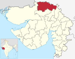
Banaskantha district | |
|---|---|
 Location of Banaskantha district in Gujarat | |
| Coordinates: 24°10′23″N 72°25′53″E / 24.17306°N 72.43139°E | |
| Country | |
| State | Gujarat |
| Named for | Banas River |
| Headquarters | Palanpur |
| Area | |
| • Total | 12,703 km2 (4,905 sq mi) |
| Population (2011)[1] | |
| • Total | 3,120,506 |
| • Rank | 111 of 640 in India 5 of 26 in Gujarat |
| • Density | 250/km2 (640/sq mi) |
| Languages | |
| • Official | Gujarati, Hindi |
| Time zone | UTC+5:30 (IST) |
| Vehicle registration | GJ 08 |
| Website | banaskantha |
Banaskantha district is one of the thirty-three districts of the Gujarat state of India. The administrative headquarters of the district is at Palanpur which is also its largest city. The district is located in the Northeast of Gujarat and is presumably named after the West Banas River which runs through the valley between Mount Abu and Aravalli Range, flowing to the plains of Gujarat in this region and towards the Rann of Kutch.[2] The district is famous for the Ambaji temple which draws many tourists.[3] It covers an area of 12703 km2 and is the second largest district in the state.
- ^ "District Census Hand Book – Banas Kantha" (PDF). Census of India. Registrar General and Census Commissioner of India.
- ^ "Archived copy". Archived from the original on 2017-02-24. Retrieved 2017-02-23.
{{cite web}}: CS1 maint: archived copy as title (link) - ^ "Archived copy". Archived from the original on 2017-02-28. Retrieved 2017-02-27.
{{cite web}}: CS1 maint: archived copy as title (link)


