Bang Rak
บางรัก | |
|---|---|
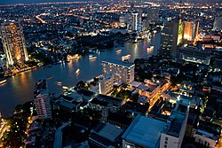
 Night view showing the Bang Rak area on the near side of the river | |
 Location in Bang Rak District | |
| Country | |
| Province | Bangkok |
| Khet | Bang Rak |
| Area | |
• Total | 0.689 km2 (0.266 sq mi) |
| Population (2020) | |
• Total | 2,672 |
| Time zone | UTC+7 (ICT) |
| Postal code | 10500 |
| TIS 1099 | 100404 |
Bang Rak (Thai: บางรัก, pronounced [bāːŋ rák]) is a khwaeng (subdistrict) and historic neighbourhood in Bangkok's Bang Rak District. It lies between the Chao Phraya River and Charoen Krung Road, and was home to communities of European expatriates who settled in the area mostly during the second half of the 19th century as Siam (as Thailand was then known) opened up to the West. Among them were the Portuguese, French and British, whose embassies occupied extensive grounds in the area, Danes who founded shipping companies as well as the historic Oriental Hotel, and Catholic missionaries who established some of the first schools in the country on the grounds surrounding Assumption Cathedral.
Bang Rak was among the city's busiest commercial neighbourhoods at the turn of the 19th–20th centuries, but declined in prominence as newer development soon moved elsewhere. Beginning in the 2010s, urban revitalization efforts have led the area to become known as the Charoenkrung Creative District, a project led by the Thailand Creative & Design Center, which re-established its headquarters at the Grand Postal Building in 2017.
- ^ Administrative Strategy Division, Strategy and Evaluation Department, Bangkok Metropolitan Administration (2021). สถิติกรุงเทพมหานครประจำปี 2563 [Bangkok Statistics 2020] (PDF) (in Thai). Retrieved 27 November 2021.
{{cite web}}: CS1 maint: multiple names: authors list (link)