Bangkok Yai
บางกอกใหญ่ | |
|---|---|
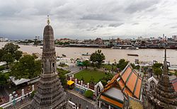
 Area around Wat Arun (taken photo from Prang of Wat Arun), across the Chao Phraya River is Phra Nakhon's Tha Tian neighbourhood | |
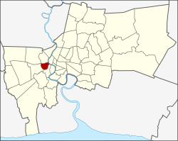
 Khet location in Bangkok | |
| Coordinates: 13°43′22″N 100°28′35″E / 13.72278°N 100.47639°E | |
| Country | |
| Province | Bangkok |
| Seat | Wat Tha Phra |
| Khwaeng | 2 |
| Area | |
• Total | 6.18 km2 (2.39 sq mi) |
| Population (2017) | |
• Total | 67,768[1] |
| • Density | 10,965.69/km2 (28,401.0/sq mi) |
| Time zone | UTC+7 (ICT) |
| Postal code | 10600 |
| Geocode | 1016 |
Bangkok Yai (Thai: บางกอกใหญ่, pronounced [bāːŋ.kɔ̀ːk jàj]) is one of the 50 districts (khet) of Bangkok, Thailand. Neighbouring districts are (from north clockwise) Bangkok Noi, Phra Nakhon (across Chao Phraya River), Thon Buri, Phasi Charoen, and Taling Chan.
- ^ "Population and House Report for Year 2017". Department of Provincial Administration, Ministry of Internal Affairs. Retrieved 1 April 2018. (Search page)