This article needs additional citations for verification. (January 2024) |
Banihal | |
|---|---|
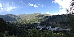
 Banihal Pass in Ramban district (J&K) | |
| Coordinates: 33°25′N 75°12′E / 33.42°N 75.2°E | |
| Country | |
| Union Territory | Jammu and Kashmir |
| Region | Chenab Valley |
| District | Ramban |
| Elevation | 1,647 m (5,404 ft) |
| Population (2011) | |
| • Total | 3,900 |
| Languages | |
| • Official | Kashmiri, Urdu, Hindi, Dogri, English[1][2] |
| • Spoken | Kashmiri |
| Time zone | UTC+5:30 (ISTfrr) |
| Pincode | 182146 |
| Vehicle registration | JK-19 |
| Website | ramban |
Banihal is a town and a notified area committee, near Ramban town in Ramban district in the Indian union territory of Jammu and Kashmir. It is a rural and hilly area with Kamirwah being one of the most prominent hills. It is located about 35 km (22 mi) away from Qazigund of Anantnag district on NH 44 (former name NH 1A before renumbering of all national highways). However, the distance between Banihal and Qazigund is only 18 km by train on the new railway line which is much shorter than the road. The most common language spoken in the region is Kashmiri; Urdu, Hindi, Gujjari, Pahari and English are other familiar languages.
- ^ "The Jammu and Kashmir Official Languages Act, 2020" (PDF). The Gazette of India. 27 September 2020. Retrieved 27 September 2020.
- ^ "Parliament passes JK Official Languages Bill, 2020". Rising Kashmir. 23 September 2020. Archived from the original on 24 September 2020. Retrieved 23 September 2020.

