Banks, Oregon | |
|---|---|
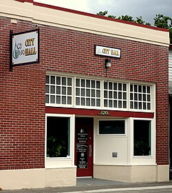
 City Hall in Banks | |
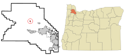
 Location in Oregon | |
| Coordinates: 45°36′54″N 123°06′25″W / 45.61500°N 123.10694°W | |
| Country | United States |
| State | Oregon |
| County | Washington |
| Incorporated | January 16, 1906 |
| Government | |
| • Mayor | Stephanie Jones [citation needed] |
| Area | |
• Total | 0.76 sq mi (1.97 km2) |
| • Land | 0.76 sq mi (1.97 km2) |
| • Water | 0.00 sq mi (0.00 km2) |
| Elevation | 213 ft (65 m) |
| Population | |
• Total | 1,837 |
| • Density | 2,410.76/sq mi (931.32/km2) |
| Time zone | UTC-8 (Pacific) |
| • Summer (DST) | UTC-7 (Pacific) |
| ZIP codes | 97106, 97109, 97125 |
| Area code | 503 |
| FIPS code | 41-03850[4] |
| GNIS feature ID | 2409784[2] |
| Website | www.cityofbanks.org |
Banks is a city in Washington County, Oregon, United States, which is located in the Tualatin Valley. It is the southern anchor to the Banks–Vernonia State Trail, which is a 21-mile-long (34 km) linear trail popular with bicyclists, hikers, and equestrians. The population was 1,777 at the 2010 census.[4] The community was named for John and Nancy Banks, who owned a nearby dairy farm.[5] Incorporated in 1921, it is located in the western part of the county where Oregon Route 6 intersects Oregon Route 47.
- ^ "ArcGIS REST Services Directory". United States Census Bureau. Retrieved October 12, 2022.
- ^ a b U.S. Geological Survey Geographic Names Information System: Banks, Oregon
- ^ Cite error: The named reference
USCensusDecennial2020CenPopScriptOnlywas invoked but never defined (see the help page). - ^ a b Cite error: The named reference
wwwcensusgovwas invoked but never defined (see the help page). - ^ "About Us". City of Banks. 2009. Retrieved April 11, 2015.
