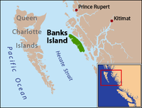
Native name: Ḵaa'al | |
|---|---|
 Banks Island is located on the east side of Hecate Strait | |
 | |
| Geography | |
| Location | Hecate Strait |
| Coordinates | 53°25′N 130°10′W / 53.417°N 130.167°W |
| Area | 1,005 km2 (388 sq mi) |
| Length | 72 km (44.7 mi) |
| Width | 9.7–18 km (6.0–11.2 mi) |
| Highest elevation | 536 m (1759 ft) |
| Highest point | unnamed |
| Administration | |
| Province | British Columbia |
Banks Island is an island on the coast of the Canadian province of British Columbia. It is located south of Prince Rupert, on Hecate Strait, east of and opposite Haida Gwaii. To its east is Pitt Island and McCauley Island, both across Principe Channel. To its west is Bonilla Island. To its south lies the archipelago of the Estevan Group, beyond which is Caamaño Sound.
Banks Island is 72 kilometres (45 mi) long and ranges in width from 9.7 kilometres (6.0 mi) to 18 kilometres (11 mi). It is 1,005 square kilometres (388 sq mi) in area. It reaches 536 metres (1,759 ft) in elevation.[1] It is located within the Skeena-Queen Charlotte Regional District. The Banks Nii Łuutiksm Conservancy is located on the north end of the island.
Banks Island was named in 1787 by Archibald Menzies,[2] botanist and surgeon of the fur trading vessel Princess Royal, in honour of Sir Joseph Banks, who was then president of the Royal Society and had accompanied James Cook during the exploratory voyages of 1768–1771.[3] Banks was instrumental in encouraging British fur trading voyages to the Pacific Northwest, such as Duncan's.
- ^ Banks Island Archived November 9, 2004, at the Wayback Machine, The Columbia Gazetteer of North America
- ^ "Menzies' Journal of Vancouver's Voyage, April to October, 1792" (PDF). Wisconsin Historical Society. 2003. Archived from the original (PDF) on 3 July 2010 – via www.americanjourneys.org.
- ^ "Banks Island". BC Geographical Names.