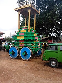
Bannur | |
|---|---|
Town | |
 | |
 | |
| Coordinates: 12°15′17″N 76°54′25″E / 12.2548°N 76.9070°E | |
| Country | |
| State | Karnataka |
| District | Mysore |
| Government | |
| • Type | Municipality |
| Elevation | 654 m (2,146 ft) |
| Population (2011) | |
• Total | 21,896 |
| Language | |
| • Official | ಕನ್ನಡ (Kannada) |
| Time zone | UTC+5:30 (IST) |
| PIN | 571101 |
| ISO 3166 code | IN-KA |
| Vehicle registration | KA-09, KA-55 |
| Website | karnataka |
Bannur is a municipality in T.Narasipura Taluk, Mysore district in the state of Karnataka, India.[1] It is located at 12°20′N 76°52′E / 12.33°N 76.86°E.[2] It has an average elevation of 654 metres (2,146 ft) T.Narasipura Taluk Near Somanathapur Temple. It is about 25 kilometers from the city of Mysuru and around 30 kilometres (19 mi)30 kilometers from Mandya
- ^ "Unauthorized Request Blocked". www.bannurtown.mrc.gov.in. Retrieved 30 June 2017.
- ^ "Maps, Weather, and Airports for Bannur, India". www.fallingrain.com. Retrieved 30 June 2017.