Bantam, Connecticut | |
|---|---|
| Borough of Bantam | |
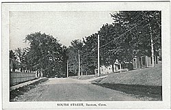
 South Street, about 1910 (postcard picture) | |
 Location in Litchfield County, Connecticut | |
| Coordinates: 41°43′24″N 73°14′26″W / 41.72333°N 73.24056°W | |
| Country | |
| U.S. state | |
| County | Litchfield |
| Region | Northwest Hills |
| Town | Litchfield |
| Area | |
| • Total | 1.01 sq mi (2.62 km2) |
| • Land | 1.01 sq mi (2.62 km2) |
| • Water | 0.00 sq mi (0.00 km2) |
| Elevation | 922 ft (281 m) |
| Population (2020) | |
| • Total | 720 |
| • Density | 719.80/sq mi (277.82/km2) |
| Time zone | UTC-5 (Eastern (EST)) |
| • Summer (DST) | UTC-4 (EDT) |
| ZIP code | 06750 |
| Area code | 860 |
| FIPS code | 09-02690 |
| GNIS feature ID | 0205245 |
| Website | bantamct |
Bantam is a borough in Litchfield County, Connecticut, United States. The population was 720 at the 2020 census. It is part of the town of Litchfield.[2]
On July 10, 1989, many of the buildings in Bantam were heavily damaged by a tornado that ripped through Litchfield and New Haven Counties.[3] The storm also caused considerable damage to the Litchfield County town of Thomaston, and to the New Haven County towns of Waterbury, Hamden and North Haven.
- ^ "2019 U.S. Gazetteer Files". United States Census Bureau. Retrieved July 2, 2020.
- ^ "About – Borough of Bantam". Retrieved November 13, 2024.
- ^ "About – Borough of Bantam". Retrieved November 13, 2024.