This article needs additional citations for verification. (August 2012) |
Bantwal | |
|---|---|
Suburb | |
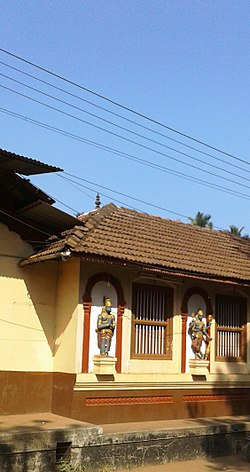
 Kashi Mutt | |
 | |
| Coordinates: 12°53′37″N 74°59′41″E / 12.8936°N 74.9947°E | |
| Country | |
| State | Karnataka |
| District | Dakshina Kannada |
| Nearest City | Mangalore |
| Area | |
• Total | 25 km2 (10 sq mi) |
| Elevation | 36 m (118 ft) |
| Population (2011[1]) | |
• Total | 40,155 |
| • Density | 1,473.2/km2 (3,816/sq mi) |
| Languages | |
| • Official | Kannada |
| Time zone | UTC+5:30 (IST) |
| PIN | 574 211 |
| Telephone code | 08255 |
| Vehicle registration | KA-70 |
| Website | www |
Bantwal () is a suburb of Mangalore in Dakshina Kannada district, Karnataka, India, and the headquarters of Bantwal taluk. It is located 25 km (16 mi) East of Mangalore city center. BC Road-Kaikamba of Bantwal is one of the fastest developing areas in Dakshina Kannada district of Karnataka.
Along with BC Road-Kaikamba, Panemangalore & Melkar regions are also urbanized. They are also developing as the eastern suburbs of Mangalore. Towards east of Mangalore, the stretch to BC Road-Kaikamba region forms a continuous Mangalore Urban Agglomeration area which is currently the second biggest in Karnataka after Bangalore. Bantwal is the fourth largest urban area in Dakshina Kannada district after Mangalore, Ullal (both comes under Mangalore Urban Agglomeration area) & Puttur in terms of population.


- ^ "Home | ಬಂಟ್ವಾಳ ಪುರಸಭೆ". Archived from the original on 21 October 2013. Retrieved 21 October 2013.