Barajevo
Барајево (Serbian) | |
|---|---|
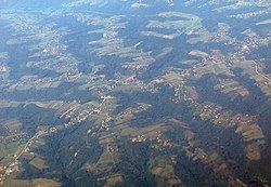
 Barajevo from air | |
 Location of Barajevo within the city of Belgrade | |
| Coordinates: 44°35′N 20°25′E / 44.583°N 20.417°E | |
| Country | |
| City | |
| Settlements | 13 |
| Government | |
| • Mayor | Bratoljub Stanisavljević (SNS) |
| Area | |
| • Village | 57.93 km2 (22.37 sq mi) |
| • Municipality | 212.96 km2 (82.22 sq mi) |
| Population (2022 census)[3] | |
| • Municipality | 26,431 |
| Time zone | UTC+1 (CET) |
| • Summer (DST) | UTC+2 (CEST) |
| Postal code | 11460 |
| Area code | +381(0)11 |
| Car plates | BG |
| Website | www |
Barajevo (Serbian Cyrillic: Барајево, pronounced [bǎrajɛv̞ɔ]) is a municipality of the city of Belgrade. According to the 2022 census results, the municipality has a population of 26,431 inhabitants.
The municipality is located in the lower northern part of Šumadija, southeast of the Belgrade, with an elevation spanning from 140 meters to 364 meters. Most of the municipal territory belongs to the drainage area of the Turija river, right tributary of the Peštan river, which in turn flows into the Kolubara, thus whole area geographically gravitates to the Kolubara region. The cultural festival, "Barlet" (Barajevo summer) is held annually in Barajevo.
- ^ "Municipalities of Serbia, 2006". Statistical Office of Serbia. Retrieved 2010-11-28.
- ^ "Насеља општине Барајево" (PDF). stat.gov.rs (in Serbian). Statistical Office of Serbia. Archived from the original (PDF) on 14 November 2015. Retrieved 23 October 2019.
- ^ "2022 Census of Population, Households and Dwellings: Ethnicity (data by municipalities and cities)" (PDF). Statistical Office of Republic Of Serbia, Belgrade. April 2023. ISBN 978-86-6161-228-2. Retrieved 2023-04-30.

