Barak Valley | |
|---|---|
| Nickname: "Valley of Peace"[1] | |
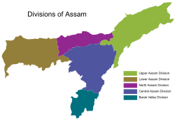
 The five divisions of Assam | |
| Country | |
| Region | North Eastern Region (NER) |
| State | Assam |
| Largest City | Silchar |
| Official language | Bengali |
| Associate official language | Meitei (Manipuri) |
| Area | |
• Total | 6,922 km2 (2,673 sq mi) |
| Population (2011 census) | |
• Total | 3,624,599 |
| • Density | 520/km2 (1,400/sq mi) |
| Demonym | "Barakbashi" |

The Barak Valley is the southernmost region and administrative division of the Indian state of Assam. It is named after the Barak river.[2] The Barak valley consists of three administrative districts of Assam namely - Cachar, Karimganj, and Hailakandi.[3] The main and largest city is Silchar, which seats the headquarter of Cachar district and also serves as administrative divisional office of Barak valley division.[4] The valley is bordered by Mizoram and Tripura to the south, Bangladesh and Meghalaya to the west and Manipur to the east respectively.[5] Once North Cachar Hills was a part of Cachar district which became a subdivision in 1951 and eventually a separate district.[6] On 1 July 1983, Karimganj district was curved out from the eponymous subdivision of Cachar district. In 1989 the subdivision of Hailakandi was upgraded into Hailakandi district.[7]

- ^ Ghildiyal, Subodh (18 April 2019). "Why Priyanka campaigned in Silchar". The Times of India. Retrieved 19 April 2024.
- ^ (Tunga 1995, p. 1)
- ^ "Districts". assam.gov.in/about-us/396.
- ^ "Districts | Assam State Portal". assam.gov.in.
- ^ "List of all the Districts and Regional Divisions in Assam". Pratidin Time. 23 March 2023.
- ^ "History of Cachar | Cachar District | Government Of Assam, India". Cachar.gov.in. Retrieved 11 August 2022.
- ^ "History of Cachar | Cachar District | Government Of Assam, India". cachar.gov.in.