 Location of Livingston Island in the South Shetland Islands
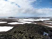 Barclay Bay and Robbery Beaches from near Basalt Lake on Byers Peninsula, Livingston Island. Visible from left to right are Lair Point, Frederick Rocks, Cutler Stack, Nedelya Point and the northern part of Urvich Wall in the middle ground, and Cape Shirreff and Ioannes Paulus II Peninsula in the right background.
Barclay Bay (62°33′S 60°58′W / 62.550°S 60.967°W / -62.550; -60.967) is a bay in the Drake Passage between Cape Shirreff and Essex Point on the north side of Livingston Island, in the South Shetland Islands. Its head is fed by Etar Snowfield. The name appears on an 1825 chart of the British sealing expedition under James Weddell, and is now established in international usage.

