Barpeta district | |
|---|---|
 | |
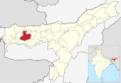
 Location in Assam | |
| Coordinates: 26°32′N 91°00′E / 26.533°N 91.000°E | |
| Country | |
| State | Assam |
| Division | Lower Assam |
| Headquarters | Barpeta |
| Government | |
| • Lok Sabha constituencies | Barpeta |
| • Vidhan Sabha constituencies | Sorbhog, Barpeta, Jania, Baghbar, Sarukhetri, Chenga |
| Area | |
• Total | 2,764 km2 (1,067 sq mi) |
| Population (2011) | |
• Total | 1,439,806 |
| • Density | 520/km2 (1,300/sq mi) |
| Time zone | UTC+05:30 (IST) |
| ISO 3166 code | IN-AS-BA |
| Website | https://barpeta.assam.gov.in/ |
Barpeta district is an administrative district in the state of Assam in India. The district headquarters are located at Barpeta. The district occupies an area of 3,245 km2 (1,253 sq mi) and has a population of 1,642,420 (as of 2001).
