This article needs additional citations for verification. (May 2018) |


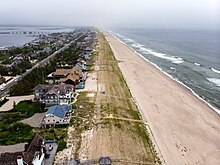
Barrier islands are a coastal landform, a type of dune system and sand island, where an area of sand has been formed by wave and tidal action parallel to the mainland coast.[1] They usually occur in chains, consisting of anything from a few islands to more than a dozen. They are subject to change during storms and other action, but absorb energy and protect the coastlines and create areas of protected waters where wetlands may flourish. A barrier chain may extend for hundreds of kilometers, with islands periodically separated by tidal inlets. The largest barrier island in the world is Padre Island of Texas, United States, at 113 miles (182 km) long.[2] Sometimes an important inlet may close permanently, transforming an island into a peninsula, thus creating a barrier peninsula,[3] often including a beach, barrier beach. Though many are long and narrow, the length and width of barriers and overall morphology of barrier coasts are related to parameters including tidal range, wave energy, sediment supply, sea-level trends, and basement controls.[4] The amount of vegetation on the barrier has a large impact on the height and evolution of the island.[5]
Chains of barrier islands can be found along approximately 13-15% of the world's coastlines.[6] They display different settings, suggesting that they can form and be maintained in a variety of environments. Numerous theories have been given to explain their formation.
A human-made offshore structure constructed parallel to the shore is called a breakwater. In terms of coastal morphodynamics, it acts similarly to a naturally occurring barrier island by dissipating and reducing the energy of the waves and currents striking the coast. Hence, it is an important aspect of coastal engineering.
- ^ US Department of Commerce, National Oceanic and Atmospheric Administration. "What is a barrier island?". oceanservice.noaa.gov. Retrieved 2024-06-21.
- ^ Garrison, J.R., Jr., Williams, J., Potter Miller, S., Weber, E.T., II, McMechan, G., and Zeng, X., 2010, "Ground-penetrating radar study of North Padre Island; Implications for barrier island interval architecture, model for growth of progradational microtidal barrier islands, and Gulf of Mexico sea-level cyclicity:" Journal of Sedimentary Research,' v. 80, p. 303–319.
- ^ Blevins, D. (2017). North Carolina's Barrier Islands: Wonders of Sand, Sea, and Sky. University of North Carolina Press. p. 3. ISBN 978-1-4696-3250-6. Retrieved 2020-09-15.
- ^ Davis & FitzGerald (2004), p. 144.
- ^ Durán Vinent, Orencio; Moore, Laura J. (2015). "Barrier island bistability induced by biophysical interactions". Nature Climate Change. 5 (2): 158–162. Bibcode:2015NatCC...5..158D. doi:10.1038/nclimate2474.
- ^ Smith, Q.H.T., Heap, A.D., and Nichol, S.L., 2010, "Origin and formation of an estuarine barrier island, Tapora Island, New Zealand:" Journal of Coastal Research, v. 26, p. 292–300.