| Barron River French: Rivière Barron | |
|---|---|
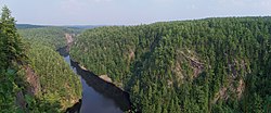
 View of the Barron River looking downstream from the top of the Barron Canyon | |
| Location | |
| Country | Canada |
| Province | Ontario |
| District/County | |
| Physical characteristics | |
| Source | Clemow Lake |
| • location | Barron Township, Unorg. South Nipissing, Nipissing District, Northeastern Ontario |
| • coordinates | 45°54′24″N 77°53′37″W / 45.90667°N 77.89361°W |
| • elevation | 225 m (738 ft) |
| Mouth | Lac du Bois Dur, Petawawa River |
• location | Laurentian Hills, Renfrew County, Eastern Ontario |
• coordinates | 45°52′48″N 77°23′40″W / 45.88000°N 77.39444°W |
• elevation | 139 m (456 ft) |
| Basin features | |
| River system | Saint Lawrence River drainage basin |
| Tributaries | |
| • left | Mulock Creek, Carcajou Creek |
The Barron River (French: rivière Barron) is a river in the Saint Lawrence River drainage basin in Nipissing District and Renfrew County, Ontario, Canada. It flows from Clemow Lake in northern Algonquin Provincial Park and joins the Petawawa River, whose southern branch it forms, in the municipality of Laurentian Hills, near the municipality of Petawawa.[1][2]
The river is named after Barron Township through which it flows, which in turn was named in honour of John Augustus Barron.[3]
A popular canoe route passes through and a hiking trail leads to the edge of the Barron Canyon.
- ^ "Barron River". Geographical Names Data Base. Natural Resources Canada. Retrieved 2011-02-21.
- ^ "Barron River". Atlas of Canada. Natural Resources Canada. 2010-02-04. Retrieved 2011-08-09. Shows the river course.
- ^ Sessional Papers of the Dominion of Canada. Vol. 53. Parliament of Canada. 1918. Retrieved 13 September 2021.
