Bartlett, New Hampshire | |
|---|---|
Town | |
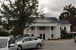
 Bartlett Elementary School and Library | |
| Motto: "In the Heart of the White Mountains" | |
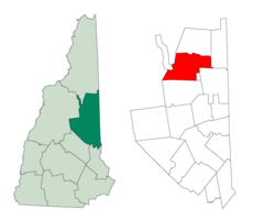
 Location in Carroll County, New Hampshire | |
| Coordinates: 44°04′40″N 71°16′58″W / 44.07778°N 71.28278°W | |
| Country | United States |
| State | New Hampshire |
| County | Carroll |
| Incorporated | 1790 |
| Villages | |
| Government | |
| • Board of Selectmen |
|
| Area | |
• Total | 75.2 sq mi (194.8 km2) |
| • Land | 74.8 sq mi (193.7 km2) |
| • Water | 0.4 sq mi (1.1 km2) 0.57% |
| Elevation | 671 ft (205 m) |
| Population (2020)[2] | |
• Total | 3,200 |
| • Density | 43/sq mi (16.5/km2) |
| Time zone | UTC-5 (Eastern) |
| • Summer (DST) | UTC-4 (Eastern) |
| ZIP codes | |
| Area code | 603 |
| FIPS code | 33-03700 |
| GNIS feature ID | 0873539 |
| Website | townofbartlettnh |
Bartlett is a town in Carroll County, New Hampshire, United States. The population was 3,200 at the 2020 census,[2] up from 2,788 at the 2010 census.[3] Bartlett includes the unincorporated community of Glen as well as portions of the communities of Kearsarge and Intervale, which the town shares with the neighboring town of Conway. It is set in the White Mountains and is surrounded by the White Mountain National Forest. It is home to the Attitash Mountain Resort and the Story Land theme park.
The main village in town, where 351 people resided at the 2020 census, is defined by the U.S. Census Bureau as the Bartlett census-designated place and is located at the intersection of U.S. Route 302 with Bear Notch Road (Albany Avenue).
- ^ "2020 U.S. Gazetteer Files – New Hampshire". United States Census Bureau. Retrieved October 29, 2021.
- ^ a b "Bartlett town, Carroll County, New Hampshire: 2020 DEC Redistricting Data (PL 94-171)". U.S. Census Bureau. Retrieved October 29, 2021.
- ^ United States Census Bureau, American FactFinder, 2010 Census figures. Retrieved March 23, 2011.