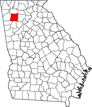
Bartow County | |
|---|---|
 Bartow County Courthouse and Confederate Monument | |
 Location within the U.S. state of Georgia | |
 Georgia's location within the U.S. | |
| Coordinates: 34°14′N 84°50′W / 34.24°N 84.84°W | |
| Country | |
| State | |
| Founded | December 3, 1832 |
| Named for | Francis S. Bartow |
| Seat | Cartersville |
| Largest city | Cartersville |
| Area | |
• Total | 470 sq mi (1,200 km2) |
| • Land | 460 sq mi (1,200 km2) |
| • Water | 11 sq mi (30 km2) 2.2% |
| Population (2020) | |
• Total | 108,901 |
• Estimate (2023) | 115,041 |
| • Density | 230/sq mi (89/km2) |
| Time zone | UTC−5 (Eastern) |
| • Summer (DST) | UTC−4 (EDT) |
| Congressional district | 11th |
| Website | bartowcountyga.gov |
Bartow County is in the Northwest region of the U.S. state of Georgia. As of the 2020 census, the population was 108,901, up from 100,157 in 2010.[1] The county seat is Cartersville.[2] Traditionally considered part of northwest Georgia, Bartow County is now included in the Atlanta metropolitan area, mainly in the southeastern part near Cartersville, which has become an exurb more than 40 miles (64 km) from downtown Atlanta on I-75. It has a sole commissioner government, and is the largest county by population of the few remaining in Georgia with a sole commissioner.
- ^ "State & County QuickFacts". United States Census Bureau. Archived from the original on July 3, 2011. Retrieved June 18, 2014.
- ^ "Find a County". National Association of Counties. Archived from the original on July 12, 2012. Retrieved June 7, 2011.

