22°01′29″N 74°55′05″E / 22.02485°N 74.91805°E
Barwani district | |
|---|---|
top - Vaishno mata Mandir,
Bottom - Sunset over hills in Barwani | |
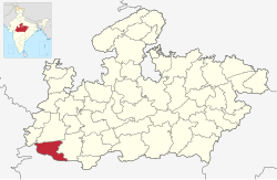
 Location of Barwani district in Madhya Pradesh | |
| Country | |
| State | Madhya Pradesh |
| Division | Indore |
| Established | 25 May 1998 |
| Headquarters | Barwani |
| Tehsils | |
| Government | |
| • District collector | Shivraj Singh Verma (IAS) |
| • Lok Sabha constituencies | 1. Khargone (shared with Barwani district) |
| • Vidhan Sabha constituencies | 4 |
| Area | |
| • Total | 5,427 km2 (2,095 sq mi) |
| Population (2011) | |
| • Total | 1,385,881 |
| • Density | 260/km2 (660/sq mi) |
| • Urban | 14.72% |
| Demographics | |
| • Literacy | 49.08% |
| • Sex ratio | 982 |
| Time zone | UTC+05:30 (IST) |
| Vehicle registration | MP-46 |
| Major highways | MP SH 26 MP SH 36 |
| Website | barwani |
Barwani district is one of the districts of Madhya Pradesh state of India. The administrative headquarters of the district is at Barwani. Barwani district has an area of 5,427 km² and a population 1,385,881 (2011 census). The district lies in the southwestern corner of Madhya Pradesh; the Narmada River forms its northern boundary. The Satpura Range lies to its south. The district is bordered by Maharashtra state to the south, Gujarat state to the west, Dhar District to the north and Khargone District to the east.

