| Bass | |
|---|---|
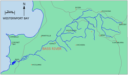
 Map of Bass River, Victoria | |
| Etymology | In honour of George Bass |
| Native name |
|
| Location | |
| Country | Australia |
| State | Victoria |
| Region | South East Coastal Plain (IBRA), West Gippsland |
| Local government area | Bass Coast Shire |
| Physical characteristics | |
| Source | Strzelecki Ranges |
| • location | below Woodleigh |
| • coordinates | 38°22′27″S 145°39′29″E / 38.37417°S 145.65806°E |
| • elevation | 60 m (200 ft) |
| Mouth | Western Port |
• location | west of Bass |
• coordinates | 38°29′46″S 145°25′54″E / 38.49611°S 145.43167°E |
• elevation | 0 m (0 ft) |
| Length | 59 km (37 mi) |
| Discharge | |
| • location | mouth |
| Basin features | |
| River system | Western Port catchment |
| Tributaries | |
| • left | Wattle Creek |
| [3] | |
The Bass River, a perennial river of the Western Port catchment, is located in the West Gippsland region of the Australian state of Victoria.
- ^ "Bass River: 10130: Traditional Name: Weandon yallock". Vicnames. Government of Victoria. 12 August 2011. Archived from the original on 1 March 2014. Retrieved 25 February 2014.
- ^ "Bass River: 10130: Traditional Name: Tullungurn". Vicnames. Government of Victoria. 12 August 2011. Archived from the original on 1 March 2014. Retrieved 25 February 2014.
- ^ "Map of Bass River, VIC". Bonzle Digital Atlas of Australia. Retrieved 25 February 2014.
