Batang County
巴塘县 · འབའ་ཐང་རྫོང་། | |
|---|---|
 Twin lakes in Batang, Sichuan | |
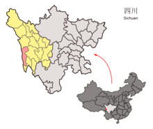
 Location of Batang County (red) in the Garzê Tibetan Autonomous Prefecture (yellow) and Sichuan | |
| Coordinates (Batang County government): 30°01′12″N 99°15′00″E / 30.02000°N 99.25000°E | |
| Country | China |
| Province | Sichuan |
| Prefecture | Garzê |
| County seat | Qakyung (Batang) |
| Area | |
| • Total | 7,852 km2 (3,032 sq mi) |
| Population (2020)[1] | |
| • Total | 49,967 |
| • Density | 6.4/km2 (16/sq mi) |
| Time zone | UTC+8 (China Standard) |
| Area code | 0836[2] |
| Website | www |
| Batang County | |||||||||||
|---|---|---|---|---|---|---|---|---|---|---|---|
| Chinese name | |||||||||||
| Simplified Chinese | 巴塘县 | ||||||||||
| Traditional Chinese | 巴塘縣 | ||||||||||
| |||||||||||
| Tibetan name | |||||||||||
| Tibetan | འབའ་ཐང་རྫོང་། | ||||||||||
| |||||||||||
Batang County (Tibetan: འབའ་ཐང་རྫོང་།; Chinese: 巴塘县) is a county located in western Garzê Tibetan Autonomous Prefecture, Sichuan Province, China. The main administrative centre is known as Batang Town (officially: Xiaqiong or Qakyung).
1990 statistics give its population as 47,256, with 42,044 living in rural areas and 5,212 living in urban areas. The nationalities mainly consist of Tibetans, Hans, and Yis, Hui, and Qiang. By far the most numerous group are the Tibetans whose population is given as 44,601. It is 260 km (160 mi) from north to south and 45 km (28 mi) west to east and has an area of 8,186 km2 (3,161 sq mi).
It borders on Xiangcheng County and Litang County in the east. Derong County to the south, Markam and Gonjo counties of Tibet and Dêqên County of Yunnan in the west, across the Jinsha or "Golden Sands" River (the upper course of the Yangtze). It borders Baiyu County to the north.[3]
It is warmer here than most of Tibet (because of the lower altitude) and is reported to be a friendly, easy-going place, surrounded by barley fields.[4][5] The plain surrounding the town is unusually fertile and produces two harvests a year. The main products include: rice, maize, barley, wheat, peas, cabbages, turnips, onions, grapes, pomegranates, peaches, apricots, water melons and honey. There are also cinnabar (mercury sulphide) mines from which mercury is extracted.[6]
The low-lying Batang Valley (altitude about 2,740 m) was one of the few regions of Tibet with a Chinese settlement before 1950. There were American Protestant and French Catholic missions here focused on medical and educational projects. "Many Bapa (natives of Batang) acquired high bureaucratic positions following the Chinese occupation in consequence of their familiarity with the Chinese language and modern education."[3]
- ^ "甘孜州第七次全国人口普查公报(第二号)" (in Chinese). Government of Garzê Prefecture. 2021-06-04.
- ^ ["Batang County." "HXpedia - China's Administrative Division". Archived from the original on 2009-08-16. Retrieved 2007-12-30.]
- ^ a b "Brief Introduction of Batang county." Archived August 16, 2009, at the Wayback Machine
- ^ Mayhew, Bradley and Kohn, Michael. (2005). Tibet. 6th Edition, p. 260. Lonely Planet. ISBN 1-74059-523-8.
- ^ Buckley, Michael and Straus, Robert. (1986) Tibet: a travel survival kit, p, 219. Lonely Planet Publications. South Yarra, Victoria, Australia. ISBN 0-908086-88-1.
- ^ Huc, Évariste Régis (1853), Hazlitt, William (ed.), Travels in Tartary, Thibet, and China during the Years 1844–5–6, London: National Illustrated Library, pp. 122–123.

