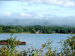
Batchawana Bay | |
|---|---|
 | |
| Etymology: Badjiwanung Ojibwe for "water that bubbles up" | |
| Coordinates: 46°55′34″N 84°36′23″W / 46.92611°N 84.60639°W[1] | |
| Country | Canada |
| Province | Ontario |
| District | Algoma |
| Time zone | UTC-5 (Eastern Time Zone) |
| • Summer (DST) | UTC-4 (Eastern Time Zone) |
| Postal code | P0S 1A0 |
| Area codes | 705, 249 |
Batchawana Bay is an unincorporated place and Compact Rural Community in Algoma District in Northeastern Ontario, Canada.[1][2][3][4] It is also the name of a local services board, consisting of parts of the geographic townships of Fisher, Herrick, Ryan and Tilley.[5] It is located north of Sault Ste. Marie, Ontario, on the shores of Batchawana Bay[6] off Lake Superior.
The area is counted as part of Unorganized North Algoma District in Statistics Canada census data.
Batchawana Bay Provincial Park is nearby along Highway 17;[7][8] the community itself is reached from Highway 17 by Ontario Highway 563.
- ^ a b "Batchawana Bay". Geographical Names Data Base. Natural Resources Canada. Retrieved 2018-07-01. (community)
- ^ "CLAIMaps IV". Ontario Ministry of Northern Development and Mines. 2016. Retrieved 2018-07-01.
- ^ Map 12 (PDF) (Map). 1 : 1,600,000. Official road map of Ontario. Ministry of Transportation of Ontario. 2016-01-01. Retrieved 2018-07-01.
- ^ Restructured municipalities - Ontario map #4 (Map). Restructuring Maps of Ontario. Ontario Ministry of Municipal Affairs and Housing. 2006. Archived from the original on 2014-04-10. Retrieved 2018-07-01.
- ^ Local Services Boards, R.R.O. 1990, Reg. 737 Archived 2014-03-10 at the Wayback Machine. Canadian Legal Information Institute.
- ^ "Batchawana Bay". Geographical Names Data Base. Natural Resources Canada. Retrieved 2018-07-01. (bay)
- ^ "Batchawana Bay Provincial Park". Geographical Names Data Base. Natural Resources Canada. Retrieved 2018-07-01. (park)
- ^ "Batchawana Bay". Ontario Parks. Retrieved 2018-07-01.
