| Battery Point Hobart, Tasmania | |||||||||||||||
|---|---|---|---|---|---|---|---|---|---|---|---|---|---|---|---|
 An assortment of weatherboard and brick row houses in Battery Point | |||||||||||||||
 | |||||||||||||||
| Coordinates | 42°53′34″S 147°20′0″E / 42.89278°S 147.33333°E | ||||||||||||||
| Population | 2,096 (SAL 2021)[1] | ||||||||||||||
| • Density | 2,995.7/km2 (7,759/sq mi) | ||||||||||||||
| Postcode(s) | 7004 | ||||||||||||||
| Area | 0.7 km2 (0.3 sq mi) | ||||||||||||||
| LGA(s) | City of Hobart | ||||||||||||||
| State electorate(s) | Clark | ||||||||||||||
| Federal division(s) | Clark | ||||||||||||||
| |||||||||||||||
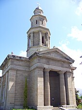
Battery Point (/ˈbætəripɔɪnt/) BAT-ə-ree-POINT is a suburb of the city of Hobart, Tasmania, Australia. It is immediately south of the central business district. It is in the local government area of City of Hobart.
Battery Point is named after the battery of guns which were established on the point in 1818 as part of the Hobart coastal defences.[2] The battery was situated on the site of today's Princes Park. The guns were used to fire salutes on ceremonial occasions but were never called upon to repel an invasion. The battery was decommissioned after an 1878 review of Hobart's defences found that its location would tend to draw an enemy's fire onto the surrounding residential neighbourhood. The site was subsequently handed over to the Hobart City Council as a place of recreation and amusement. When the Council carried out works to beautify the park in 1934, they discovered tunnels which had served as a magazine for the original battery.[3] In 1973, a green ban was placed by the Builders Labourers Federation to prevent destruction of certain buildings by developers.[4]
The area is generally known as one of the city's more prestigious suburbs, with many large and extravagant homes and apartment blocks.[5] It adjoins the waterfront Salamanca area as well as the nearby prestigious suburb of Sandy Bay.

Probably the most significant is Arthur Circus with its cottages, mostly originally constructed for the officers of the garrison.
Battery Point is accessible via Hampden Road, which runs from Sandy Bay Road from the edge of the city.

Battery Point residents have been the centre of controversy in recent years, demanding noise restrictions and other measures aimed at safeguarding a sheltered lifestyle.[8]
- ^ Australian Bureau of Statistics (28 June 2022). "Battery Point (suburb and locality)". Australian Census 2021 QuickStats. Retrieved 28 June 2022.
- ^ "Walking Battery Point". Discover Tasmania. Retrieved 18 January 2022.
- ^ Howatson, Donald, The Story of Battery Point – Street by Street, 2012, ISBN 978-0-9871287-4-4
- ^ Burgmann, Verity and Meredith (1998). Green Bans, Red Union: Environmental Activism and the New South Wales Builders Labourers' Federation. p. 52.
- ^ Sixty front doors : Battery Point Hobart : a tour guide, Richard Lord and Partners, 2005, retrieved 8 December 2018
- ^ Bennett, A. Allan (1938), St George's Church, Battery Point, Hobart, 1838–1938 : souvenir booklet giving a brief history of the century, Cox Kay, retrieved 8 December 2018
- ^ Historic Battery Point, Hobart, D.E. Wilkinson, Government Printer, 1966, retrieved 8 December 2018
- ^ PM – Cafe gets roasting for coffee bean smell
