You can help expand this article with text translated from the corresponding article in German. (December 2010) Click [show] for important translation instructions.
|
Baucau | |
|---|---|
City | |
| |
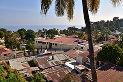
 View of the Old City, Baucau | |
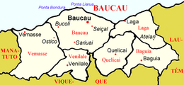
 Location in Baucau Municipality | |
| Coordinates: 8°27′46″S 126°27′13″E / 8.46278°S 126.45361°E | |
| Country | East Timor |
| Municipality | Baucau |
| Sucos (villages) | List |
| Area | |
| • Total | 369.53 km2 (142.68 sq mi) |
| Elevation | 336 m (1,102 ft) |
| Population (2015) | |
| • Total | 14,961 |
| • Density | 40/km2 (100/sq mi) |
| Time zone | UTC+09:00 (TLT) |
| Climate | Aw |
Baucau (Portuguese: Baucau, Tetum: Baukau) is the second-largest city in East Timor, after Dili, the capital, which lies 122 km (76 mi) to its west.
Baucau has about 16,000 inhabitants, and is the capital of Baucau municipality, located in the eastern part of the country. In the times of Portuguese Timor, Baucau was little more than an overgrown village,[1] and for part of those times was called Vila Salazar, after the Portuguese dictator António de Oliveira Salazar.
- ^ Gunn, Geoffrey C (2011). Historical Dictionary of East Timor. Lanham, Maryland: Scarecrow Press. pp. 48–49. ISBN 9780810867543.
