You can help expand this article with text translated from the corresponding article in German. (April 2019) Click [show] for important translation instructions.
|
| Bavarian Forest | |
|---|---|
 Effects of bark beetle in the Bavarian Forest | |
| Highest point | |
| Peak | Großer Arber (Great Arber) |
| Elevation | 4,776 ft (1,456 m) |
| Naming | |
| Native name | Bayerischer Wald (German) |
| Geography | |
| Country | Germany |
| Region | Bavaria |
| Parent range | Central Uplands Bohemian Massif |
| Geology | |
| Orogeny | Variscan |
| Rock type(s) | Metamorphic Gneiss and Granite rocks |


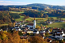
The Bavarian Forest (German: Bayerischer Wald [ˈbaɪʁɪʃɐ ˈvalt] or Bayerwald [ˈbaɪɐvalt] ; Bavarian: Boarischa Woid) is a wooded, low-mountain region in Bavaria, Germany that is about 100 kilometres long. It runs along the Czech border and is continued on the Czech side by the Bohemian Forest (Czech: Šumava). Most of the Bavarian Forest lies within the province of Lower Bavaria, but the northern part lies within Upper Palatinate. In the south it reaches the border with Upper Austria.
Geologically and geomorphologically, the Bavarian Forest is part of the Bohemian Forest - the highest of the truncated highlands of the Bohemian Massif. The area along the Czech border has been designated as the Bavarian Forest National Park (240 km2), established in 1970 as the first national park in Germany. Another 3,008 km2 has been designated as the Bavarian Forest Nature Park, established 1967, and another 1,738 km2 as the Upper Bavarian Forest Nature Park, established in 1965. The Bavarian Forest is a remnant of the Hercynian Forest that stretched across southern Germania in Roman times. It is the largest protected forest area in central Europe.[1]
The highest mountain in the region is the Großer Arber ("Great Arber", 1,456 m). The main river is the Regen, which is formed by the confluence of the White and Black Regen and flows out of the mountains towards the city of Regensburg.
