Bavlinsky District
Бавлинский район | |
|---|---|
| Other transcription(s) | |
| • Tatar | Баулы районы |
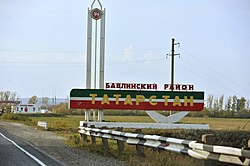
 Entrance to Bavlinsky District | |
 Location of Bavlinsky District in the Republic of Tatarstan | |
| Coordinates: 54°16′N 53°18′E / 54.267°N 53.300°E | |
| Country | Russia |
| Federal subject | Republic of Tatarstan |
| Established | 10 August 1930 |
| Administrative center | Bavly |
| Area | |
| • Total | 1,210.4 km2 (467.3 sq mi) |
| Population | |
| • Total | 14,161 |
| • Density | 12/km2 (30/sq mi) |
| • Urban | 0% |
| • Rural | 100% |
| Administrative structure | |
| • Inhabited localities | 39 rural localities |
| Municipal structure | |
| • Municipally incorporated as | Bavlinsky Municipal District |
| • Municipal divisions | 1 urban settlements, 13 rural settlements |
| Time zone | UTC+3 (MSK |
| OKTMO ID | 92614000 |
| Website | http://bavly.tatarstan.ru/ |
Bavlinsky District (Russian: Бавлинский райо́н; Tatar: Баулы районы) – is a territorial administrative unit and municipal district of the Republic of Tatarstan within the Russian Federation. The district is located in the south-east of the republic. The administrative center is the city of Bavly. As of 2020, 34,479 people reside in the district.[3]
The first mention of settlements in the region dates back to the 17th century. The Bavlinsky District was formed as part of the Tatar Autonomous Soviet Socialist Republic on August 10, 1930. In 1963 the territories of the district were transferred to Bugulminsky District. Two years later, the Bavlinsky District was reestablished as a separate administrative unit. The administrative center was the village of Bavly.[3]
- ^ Russian Federal State Statistics Service (2011). Всероссийская перепись населения 2010 года. Том 1 [2010 All-Russian Population Census, vol. 1]. Всероссийская перепись населения 2010 года [2010 All-Russia Population Census] (in Russian). Federal State Statistics Service.
- ^ "Об исчислении времени". Официальный интернет-портал правовой информации (in Russian). June 3, 2011. Retrieved January 19, 2019.
- ^ a b "Паспорт Бавлинского муниципального района" [Passport of the Bavlinsky municipal district]. Официальный сайт Бавлинского муниципального района. July 4, 2020. Archived from the original on March 1, 2021. Retrieved November 5, 2020.

