| Bay of Fundy | |
|---|---|
| Baie de Fundy | |
 The Bay of Fundy | |
| Location | New Brunswick, Nova Scotia, Maine |
| Coordinates | 45°00′N 65°45′W / 45.000°N 65.750°W |
| Type | Estuary |
| Etymology | Likely from the French Fendu, meaning "split". |
| Primary inflows | Canada and United States |
| River sources | Big Salmon, Magaguadavic, Memramcook, Petitcodiac, Quiddy, Saint John, St. Croix, Upper Salmon, Annapolis, Avon, Cornwallis, Farrells, Salmon, Shubenacadie, Kennetcook |
| Primary outflows | Gulf of Maine |
| Ocean/sea sources | Atlantic Ocean |
| References | |
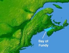
The Bay of Fundy (French: Baie de Fundy) is a bay between the Canadian provinces of New Brunswick and Nova Scotia, with a small portion touching the U.S. state of Maine. It is an arm of the Gulf of Maine. Its tidal range is the highest in the world.[1] The name is probably a corruption of the French word fendu, meaning 'split'.[2]
- ^ National Ocean Service,
- ^ Garrett, Chris; Koslow, Tony; Singh, Rabindra (March 25, 2015) [July 8, 2010]. "Fundy, Bay of and Gulf of Maine". The Canadian Encyclopedia (online ed.). Historica Canada.
