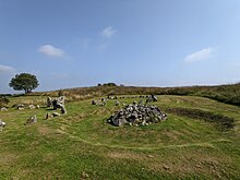


Beaghmore is a complex of early Bronze Age megalithic features, stone circles and cairns, 8.5 miles north west of Cookstown, County Tyrone in Northern Ireland, on the south-east edge of the Sperrin Mountains.[1]
Mackay's Dictionary of Ulster Place-names says that it is from Irish an Bheitheach Mhór, meaning "big place of birch trees",[2] a name that reflects the fact that the area was a woodland before being cleared by Neolithic farmers.
Beaghmore stone circles, alignments and cairns are State Care Historic Monuments in the townland of Beaghmore, in the Cookstown District Council area, grid ref: Area of H684 842.[3] At Beaghmore a cairn (grid ref: H6872 8470), a cairn (grid ref: H6856 8472), stone circles, alignments and cairns (grid ref: area of H684 842), round cairn with standing stones: Bradley's Cairn (grid ref: H6830 8401) and cairn and alignment (grid ref: H6863 8431), are all Scheduled Historic Monuments.[4]
- ^ "Beaghmore Stone Circles". The Chrono Centre – Queens University Belfast. Archived from the original on 27 May 2008. Retrieved 1 December 2007.
- ^ "Beaghmore Stone Circle Complex". Megalithics. Retrieved 1 December 2007.
- ^ "Beaghmore" (PDF). Environment and Heritage Service NI – State Care Historic Monuments. Archived from the original (PDF) on 22 July 2012. Retrieved 3 December 2007.
- ^ "Beaghmore" (PDF). Environment and Heritage Service NI – Scheduled Historic Monuments. Archived from the original (PDF) on 5 November 2008. Retrieved 3 December 2007.
