| Bear River Arroyo de los Osos[1] | |
|---|---|
 Bear River in the Sierra foothills | |
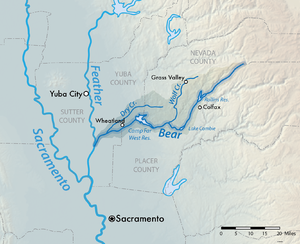
 Map of the Bear River watershed | |
| Location | |
| Country | United States |
| State | California |
| Physical characteristics | |
| Source | |
| • location | Sierra Nevada |
| • coordinates | 39°18′29″N 120°39′23″W / 39.30806°N 120.65639°W[1] |
| • elevation | 4,800 ft (1,500 m)[2] |
| Mouth | Feather River |
• location | Sacramento Valley, United States |
• coordinates | 38°56′23″N 121°34′51″W / 38.93972°N 121.58083°W[1] |
• elevation | 23 ft (7.0 m)[1] |
| Length | 73 mi (117 km) |
| Basin size | 295 sq mi (760 km2) |
| Discharge | |
| • location | Wheatland, CA |
| • average | 402 cu ft/s (11.4 m3/s) |
| • minimum | 0 cu ft/s (0 m3/s) |
| • maximum | 48,000 cu ft/s (1,400 m3/s) |
The Bear River is a tributary of the Feather River in the Sierra Nevada, winding through four California counties: Yuba, Sutter, Placer, and Nevada. About 73 miles (117 km) long, the river flows generally southwest through the Sierra then west through the Central Valley, draining a narrow, rugged watershed of 295 square miles (760 km2).
The California Office of Environmental Health Hazard Assessment has issued a safe advisory for any fish caught in Bear River due to elevated levels of mercury.[3]
- ^ a b c d "Bear River". Geographic Names Information System. United States Geological Survey, United States Department of the Interior. Retrieved February 25, 2011.
- ^ Elevation derived from Google Earth using GNIS coordinates
- ^ Admin, OEHHA (September 25, 2018). "Bear River". OEHHA. Retrieved November 6, 2018.