| Bears Paw Mountains | |
|---|---|
 Bears Paw Mountains as seen from near Virgelle, Montana | |
| Highest point | |
| Peak | Baldy Mountain |
| Elevation | 6,916 ft (2,108 m)[1] |
| Geography | |
| Country | United States |
| State | Montana |
| Range coordinates | 48°12.5′N 109°31.05′W / 48.2083°N 109.51750°W |
| Geology | |
| Rock age | Late Cretaceous |
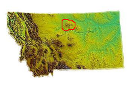
The Bears Paw Mountains (Bear Paw Mountains, Bear's Paw Mountains or Bearpaw Mountains)[2] are an insular-montane island range in the Central Montana Alkalic Province in north-central Montana, United States, located approximately 10 miles south of Havre, Montana. Baldy Mountain, which rises 6,916 feet (2,108 m) above sea level, is the highest peak in the range. The Bears Paw Mountains extend in a 45-mile arc between the Missouri River and Rocky Boy Indian Reservation south of Havre.
