| Beartooth Mountains | |
|---|---|
 | |
| Highest point | |
| Peak | Granite Peak |
| Elevation | 12,799 ft (3,901 m) |
| Coordinates | 45°09′48″N 109°48′26″W / 45.16333°N 109.80722°W |
| Geography | |
| Country | United States |
| States |
|
| Parent range | Rocky Mountains |
| Geology | |
| Orogeny | Laramide |
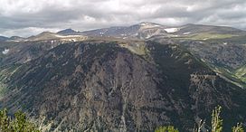
The Beartooth Mountains are located in south central Montana and northwest Wyoming, U.S. and are part of the 944,000 acres (382,000 ha) Absaroka-Beartooth Wilderness, within Custer, Gallatin and Shoshone National Forests. The Beartooths are the location of Granite Peak, which at 12,807 feet (3,904 m) is the highest point in the state of Montana. The mountains are just northeast of Yellowstone National Park[1] and are part of the Greater Yellowstone Ecosystem. The mountains are traversed by road via the Beartooth Highway (U.S. 212) with the highest elevation at Beartooth Pass 10,947 ft (3,337 m)). The name of the mountain range has been attributed by the U.S. Forest Service to a rugged peak found in the range, Beartooth Peak, that has the appearance of a bear's tooth. Originally, the Beartooth Mountains were named after Beartooth Butte, a large block of paleozoic sediments on the Beartooth Plateau, and Beartooth Butte was named for a tooth-like structure that projects from the front of the butte.
The Beartooth Mountains sit upon the larger Beartooth Plateau.

