Beaufort County | |
|---|---|
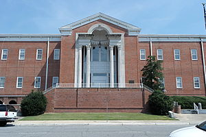
 Beaufort County Courthouse | |
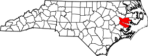
 Location within the U.S. state of North Carolina | |
 North Carolina's location within the U.S. | |
| Coordinates: 35°29′N 76°50′W / 35.48°N 76.84°W | |
| Country | |
| State | |
| Founded | 1712 |
| Named for | Henry, Duke of Beaufort |
| Seat | Washington |
| Largest community | Washington |
| Area | |
| • Total | 962.85 sq mi (2,493.8 km2) |
| • Land | 832.74 sq mi (2,156.8 km2) |
| • Water | 130.11 sq mi (337.0 km2) 13.51% |
| Population (2020) | |
| • Total | 44,652 |
| • Estimate (2023) | 44,481 |
| • Density | 53.62/sq mi (20.70/km2) |
| Time zone | UTC−5 (Eastern) |
| • Summer (DST) | UTC−4 (EDT) |
| Congressional district | 3rd |
| Website | www |
Beaufort County (/ˈboʊfərt/ BOH-fərt) is a county located in the U.S. state of North Carolina. As of the 2020 census, the population was 44,652.[1] Its county seat is Washington.[2] The county was founded in 1705 as Pamptecough Precinct. Originally included in Bath County, it was renamed Beaufort Precinct in 1712 and became Beaufort County in 1739.[3][4]
Beaufort County comprises the Washington, NC Micropolitan Statistical Area, which is also included in the Greenville-Washington, NC Combined Statistical Area.
- ^ Cite error: The named reference
2020CensusQuickFactswas invoked but never defined (see the help page). - ^ "Find a County". National Association of Counties. Archived from the original on July 12, 2012. Retrieved June 7, 2011.
- ^ "North Carolina: Individual County Chronologies". North Carolina Atlas of Historical County Boundaries. The Newberry Library. 2009. Archived from the original on March 4, 2016. Retrieved January 20, 2015.
- ^ Peter, Bangma (2006). Powell, William S. (ed.). "Beaufort County". NCpedia. University of North Carolina Press. Retrieved January 20, 2015.

