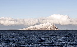
 Beaufort Island | |
| Geography | |
|---|---|
| Location | Antarctica |
| Coordinates | 76°57′S 166°57′E / 76.950°S 166.950°E |
| Archipelago | Ross Archipelago[1] |
| Area | 18.4 km2 (7.1 sq mi) |
| Highest elevation | 771 m (2530 ft) |
| Highest point | Paton Peak |
| Administration | |
| Administered under the Antarctic Treaty System | |
| Demographics | |
| Population | Uninhabited |
Beaufort Island is an island in Antarctica's Ross Sea. It is the northernmost feature of the Ross Archipelago,[1] lying 21 kilometres (13 miles) north of Cape Bird, Ross Island. It is approximately 18.4 km2 (7 square miles) in area. It was first charted by James Clark Ross in 1841. Ross named the island for Sir Francis Beaufort, hydrographer to the British Royal Navy.[2]
- ^ a b Beaufort Island TAMDEF Page Archived 21 June 2007 at archive.today, Ohio State University.
- ^ Cite error: The named reference
Stonehousewas invoked but never defined (see the help page).
