Beaver County Airport | |||||||||||
|---|---|---|---|---|---|---|---|---|---|---|---|
 | |||||||||||
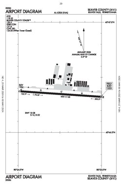
 Airport diagram | |||||||||||
| Summary | |||||||||||
| Airport type | Public | ||||||||||
| Owner | County of Beaver | ||||||||||
| Serves | Beaver, Pennsylvania, Beaver Falls, Pennsylvania, Chippewa Township, Pennsylvania | ||||||||||
| Elevation AMSL | 1,253 ft / 382 m | ||||||||||
| Coordinates | 40°46′21″N 080°23′29″W / 40.77250°N 80.39139°W | ||||||||||
| Map | |||||||||||
 | |||||||||||
| Runways | |||||||||||
| |||||||||||
| Statistics (2024) | |||||||||||
| |||||||||||
Beaver County Airport or (IATA: BFP, ICAO: KBVI, FAA LID: BVI) is a county-owned public airport three miles northwest of Beaver Falls, in Beaver County, Pennsylvania.[1]
Most U.S. airports use the same three-letter location identifier for the FAA and IATA, but Beaver County Airport is BVI to the FAA and BFP to the IATA (which assigned BVI to Birdsville Airport in Birdsville, Queensland, Australia).
- ^ a b FAA Airport Form 5010 for BVI PDF, effective 2007-10-25

