Beaver Creek | |
|---|---|
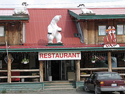
 Restaurant in Beaver Creek, Yukon | |
| Coordinates: 62°22′58″N 140°52′47″W / 62.38278°N 140.87972°W[1] | |
| Country | Canada |
| Territory | Yukon |
| Area | |
| • Land | 27.14 km2 (10.48 sq mi) |
| Elevation | 650 m (2,130 ft) |
| Population (2016)[2] | |
| • Total | 93 |
| • Density | 3.4/km2 (9/sq mi) |
| Time zone | UTC−07:00 (MST) |
| Canadian Postal code | Y0B 1A0 |
| Area code | 867 |
Beaver Creek is a community in Yukon, Canada. Located at kilometre 1870.6 (historical mile 1202) of the Alaska Highway, 1 NM (1.9 km; 1.2 mi) southeast of Beaver Creek Airport[3] and close to the Alcan - Beaver Creek Border Crossing, it is Canada's westernmost community. The community's main employers are a Canada Border Services Agency port, Royal Canadian Mounted Police Detachment, the White River First Nation and a number of tourist lodges.
It is the home of the White River First Nation. The First Nation is made up of Upper Tanana speaking people whose traditional territory extends from the Donjek River into neighbouring Alaska, and Athapaskan Northern Tutchone speaking people whose traditional territories included the lower Stewart River and the area south of the Yukon River on the White and Donjek River drainages. In addition to the Alaska Highway, the community is served by the Beaver Creek Airport.
The CBSA station is the furthest from the border crossing of any Canadian customs station at a distance of 28.6 km (17.8 mi), and at least up to the 1990s, some individuals lived in the "no man's land" in between the border and customs. Prior to 1983, the customs station was located in the middle of the community, with the resulting confusion: individuals driving past without stopping, and locals with a new vehicle not being recognized as they drove by.
- ^ "Beaver Creek". Geographical Names Data Base. Natural Resources Canada.
- ^ a b Cite error: The named reference
2011censuswas invoked but never defined (see the help page). - ^ a b Cite error: The named reference
CFSwas invoked but never defined (see the help page).

