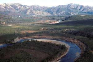
| Beaver Creek | |
|---|---|
 Beaver Creek in Yukon Flats | |
| Native name | Taatthee Niign (Upper Tanana) |
| Location | |
| Country | United States |
| State | Alaska |
| Census Area | Yukon–Koyukuk |
| Physical characteristics | |
| Source | confluence of Champion and Bear creeks |
| • location | White Mountains National Recreation Area |
| • coordinates | 65°24′56″N 146°59′04″W / 65.41556°N 146.98444°W[1] |
| Mouth | Yukon River |
• location | south-southwest (downstream) of Beaver, Yukon Flats National Wildlife Refuge |
• coordinates | 66°14′19″N 147°31′58″W / 66.23861°N 147.53278°W[1] |
• elevation | 335 ft (102 m)[1] |
| Length | 180 mi (290 km)[2] |
| Type | Wild 127 miles (204 km) |
| Designated | December 2, 1980[3] |
Beaver Creek (Upper Tanana: Taatthee Niign) is a 180-mile (290 km) tributary of the Yukon River in the U.S. state of Alaska.[2] The creek begins at the confluence of Champion and Bear creeks in the White Mountains National Recreation Area, about 50 miles (80 km) north of Fairbanks.[4][5] From there it flows west around the southern end of the White Mountains, then northeast into the Yukon Flats National Wildlife Refuge, then west into the Yukon River downstream of Beaver.[4][6]
In 1980, The Alaska National Interest Lands Conservation Act designated the upper 127 miles (204 km) of Beaver Creek as part of the National Wild and Scenic Rivers System. Most of this lies within the recreation area, but the last 16 miles (26 km) are in the wildlife refuge.[5][7]
- ^ a b c "Beaver Creek". Geographic Names Information System. United States Geological Survey. March 31, 1981. Retrieved October 29, 2013.
- ^ a b Orth, Donald J.; United States Geological Survey (1971) [1967]. Dictionary of Alaska Place Names: Geological Survey Professional Paper 567 (PDF). University of Alaska Fairbanks. p. 118. Archived from the original (PDF) on October 17, 2013. Retrieved October 29, 2013 – via United States Government Printing Office.
- ^ "National Wild and Scenic Rivers System" (PDF). rivers.gov. National Wild and Scenic Rivers System. Retrieved 2023-01-05.
- ^ a b Alaska Atlas & Gazetteer (7th ed.). Yarmouth, Maine: DeLorme. 2010. pp. 124–25, 137. ISBN 978-0-89933-289-5.
- ^ a b "Beaver Creek National Wild River". Bureau of Land Management. December 19, 2012. Archived from the original on 2013-11-01. Retrieved October 29, 2013.
- ^ "Beaver Creek recreation area details - Alaska - Recreation.gov". www.recreation.gov. Retrieved October 20, 2009.
- ^ Dapkus, Dave (1976). "Important Information About the Alaska River Logs" (PDF). U.S. Government. Retrieved October 20, 2009.
