| Beenkeragh | |
|---|---|
| Binn Chaorach | |
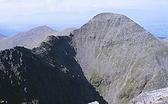
 Beenkeragh as viewed from the summit of Carrauntoohil; with the Beenkeragh Ridge (left) | |
| Highest point | |
| Elevation | 1,008.2 m (3,308 ft)[1] |
| Prominence | 90.85 m (298.1 ft)[1] |
| Listing | Furth, Hewitt, Arderin, Simm, Vandeleur-Lynam |
| Coordinates | 52°00′24″N 9°44′46″W / 52.006802°N 9.746246°W[1] |
| Geography | |
| Parent range | MacGillycuddy's Reeks |
| OSI/OSNI grid | V801852 |
| Topo map | OSI Discovery 78 |
| Geology | |
| Mountain type | Purple sandstone & siltstone, (Ballinskelligs Sandstone Formation)[1] |
| Climbing | |
| Easiest route | via Hag's Tooth Ridge |
Binn Chaorach (or Beenkeragh or Benkeeragh) (Irish: Binn Chaorach, meaning 'mountain of sheep')[2] is the second-highest peak in Ireland, at 1,008.2 metres (3,308 ft), on both the Arderin and Vandeleur-Lynam lists. It is part of the MacGillycuddy's Reeks range in County Kerry. Beenkeragh also gives its name the infamous Beenkeragh Ridge, the narrow rocky arete between Beenkeragh and Carrauntoohil, Ireland's highest mountain.
- ^ a b c d MountainViews: Beenkeragh
- ^ Paul Tempan (February 2012). "Irish Hill and Mountain Names" (PDF). MountainViews.ie.
