This article needs additional citations for verification. (September 2014) |
| Beer | |
|---|---|
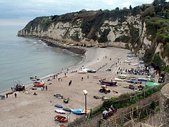
 Beach at Beer, with Beer Head behind (April 2006) | |
Location within Devon | |
| Area | 6.7 km2 (2.6 sq mi) [1] |
| Population | 1,317 (2011) |
| • Density | 197/km2 (510/sq mi) |
| OS grid reference | SY2289 |
| Civil parish |
|
| District | |
| Shire county | |
| Region | |
| Country | England |
| Sovereign state | United Kingdom |
| Post town | SEATON |
| Postcode district | EX12 |
| Dialling code | 01297 |
| Police | Devon and Cornwall |
| Fire | Devon and Somerset |
| Ambulance | South Western |
| UK Parliament | |
Beer is a seaside village and civil parish in the East Devon district of Devon, England.[3] The village faces Lyme Bay and is a little over 1 mile (1.6 km) west of the town of Seaton. It is situated on the Jurassic Coast World Heritage Site and its picturesque cliffs, including Beer Head, form part of the South West Coast Path.[4][5]
At the 2011 Census, the parish had a population of 1,317.[6]
- ^ "Hooken Cliffs - Walk - South West Coast Path". www.southwestcoastpath.org.uk.
- ^ "Home - Beer Parish Council". www.beerparishcouncil.org.uk. Archived from the original on 13 April 2018. Retrieved 12 October 2016.
- ^ "Beer, East Devon - area information, map, walks and more". OS GetOutside. Ordnance Survey. Retrieved 11 January 2018.
- ^ "Beer Head, East Devon - area information, map, walks and more". Ordnance Survey Get Outside. Retrieved 11 January 2018.
- ^ Lyme Regis & Bridport - OS Explorer Map 116 (Chard). United Kingdom: Ordnance Survey. 16 September 2015. p. 1. ISBN 9780319243176. Retrieved 11 January 2018.
- ^ "Beer (Parish): Key Figures for 2011 Census - Key Statistics". Neighbourhood Statistics. Office for National Statistics. Retrieved 12 October 2016.
