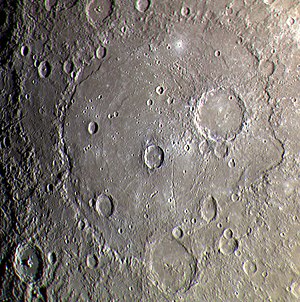


The Beethoven quadrangle is located in the equatorial region of Mercury, in the center of the area imaged by Mariner 10. Most pictures of the quadrangle were obtained at high sun angles as the Mariner 10 spacecraft receded from the planet. Geologic map units are described and classified on the basis of morphology, texture, and albedo, and they are assigned relative ages based on stratigraphic relations and on visual comparisons of the density of superposed craters. Crater ages are established by relative freshness of appearance, as indicated by topographic sharpness of their rim crests and degree of preservation of interior and exterior features such as crater floors, walls, and ejecta aprons. Generally, topography appears highly subdued because of the sun angle, and boundaries between map units are not clearly defined.
Impact craters larger than about 250 km are referred to as basins. Unlike many basins on the Moon, however, the two obvious basins in the quadrangle, Beethoven (610 km in diameter) and Raphael (320 km in diameter), are not multiringed, whereas well-developed rings encircle many craters of lesser diameters.[1] Remnant ejecta blankets around parts of the Beethoven and Raphael basins are subdued in appearance and their margins poorly defined in places. However, where they can be recognized, these extensive aprons allow a generalized regional stratigraphic sequence to be determined. A third basin, extremely subdued but probable, is centered at latitude 0°, longitude 130°.
Tolstoj quadrangle is to the west of Beethoven quadrangle, and Kuiper quadrangle is to the east. Shakespeare quadrangle and Victoria quadrangle are to the northwest and northeast, and Michelangelo quadrangle and Discovery quadrangle are to the southwest and southeast.
- ^ Trask, N.J., 1976, History of basin development on Mercury: Conference on Comparisons of Mercury and The Moon: Lunar Science Institute Contribution no. 262, p.36.