| Bega Begej / Бегеј | |
|---|---|
 Bega River in Timișoara | |
 | |
| Location | |
| Country | Romania, Serbia |
| Towns | Romania: Făget, Recaș, Timișoara Serbia: Zrenjanin, Ečka |
| Physical characteristics | |
| Source | Confluence of headwaters Bega Luncanilor and Bega Poienilor |
| • location | Poiana Ruscă Mountains, Romania |
| Mouth | Tisa river near Titel, Serbia |
• coordinates | 45°12′30″N 20°18′55″E / 45.20833°N 20.31528°E |
| Length | 244 km (152 mi) [1] |
| Basin size | 4,458 km2 (1,721 sq mi) 6,249.6 km2 (2,413.0 sq mi)[2] |
| Discharge | |
| • location | Titel, Serbia (near mouth) |
| • average | 22 m3/s (780 cu ft/s) 18.869 m3/s (666.4 cu ft/s)[3] |
| Basin features | |
| Progression | Tisza→ Danube→ Black Sea |
| Tributaries | |
| • left | Bega Luncanilor, Gladna, Bega Veche |
| • right | Bega Poienilor, Chizdia |
 | |


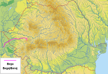
The Bega or Begej (Romanian: Bega; Serbian: Бегеј / Begej; German: Bega; Hungarian: Béga, formerly Kistemes), is a 244 km (152 mile) long river in Romania (169 km; 105 mi.) and Serbia (75 km; 47 mi.).[1][4][5] It rises in the Poiana Ruscă Mountains in Romania, part of the Carpathian Mountains, and it flows into the Tisa river near Titel, Vojvodina, Serbia. Its drainage basin covers an area of 4,458 km2 (1,721 sq mi),[6]: 22 of which 2,362 km2 (912 sq mi) in Romania.[7][5]
- ^ a b Statistical Yearbook of the Republic of Serbia 2017 (PDF) (in Serbian and English). Belgrade: Statistical Office of the Republic of Serbia. October 2017. p. 16. ISSN 0354-4206. Retrieved 30 May 2018.
- ^ "Rivers Network". 2020. Archived from the original on 12 October 2022. Retrieved 14 March 2022.
- ^ "Rivers Network". 2020. Archived from the original on 12 October 2022. Retrieved 14 March 2022.
- ^ "Planul național de management. Sinteza planurilor de management la nivel de bazine/spații hidrografice, anexa 7.1" (PDF, 5.1 MB). Administrația Națională Apele Române. 2010. pp. 473–474.
- ^ a b Atlasul cadastrului apelor din România. Partea 1 (in Romanian). Bucharest: Ministerul Mediului. 1992. pp. 199–204. OCLC 895459847. River code: V.1
- ^ Analysis of the Tisza River Basin 2007, IPCDR
- ^ Daniel Celu Vîrdol and Tudorel Andrei (eds.), Anuarul Statistic al României 2017 Romanian Statistical Yearbook (Bucharest: Institutul Național de Statistică, 2018), p. 13.