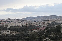
Beit Awwa | |
|---|---|
| Arabic transcription(s) | |
| • Arabic | بيت عوّا |
| • Latin | Khirbet Beit 'Awwa (official) Bayt 'Awwa (unofficial) |
 Beit Awwa, 2015 | |
Location of Beit Awwa within Palestine | |
| Coordinates: 31°30′31″N 34°57′01″E / 31.50861°N 34.95028°E | |
| Palestine grid | 145/101 |
| State | State of Palestine |
| Governorate | Hebron |
| Government | |
| • Type | Municipality |
| Area | |
| • Total | 470 dunams (0.5 km2 or 0.2 sq mi) |
| Population (2017)[1] | |
| • Total | 10,436 |
| • Density | 21,000/km2 (54,000/sq mi) |
| Name meaning | "House of Auwa"[2] |
Beit Awwa (Arabic: بيت عوّا) is a Palestinian town in the southern West Bank, in the Hebron Governorate of the State of Palestine, located 22 kilometers west of Hebron and 4 kilometers west of Dura. According to the Palestinian Central Bureau of Statistics, Beit Awwa had a population of 10,436 inhabitants in 2017.[1]
Beit Awwa saw ruins and artificial caves noted by various visitors throughout the 19th century. Following the 1948 Arab–Israeli War, it came under Jordanian rule, then Israeli occupation after the Six-Day War in 1967. Today, it is home to prominent clans, the Masalmea and Al Swaty.
- ^ a b Preliminary Results of the Population, Housing and Establishments Census, 2017 (PDF). Palestinian Central Bureau of Statistics (PCBS) (Report). State of Palestine. February 2018. pp. 64–82. Retrieved 2023-10-24.
- ^ Palmer, 1881, p. 388
