Beit Ijza | |
|---|---|
| Arabic transcription(s) | |
| • Arabic | بيت إجزا |
| • Latin | Bayt Ijza (official) |
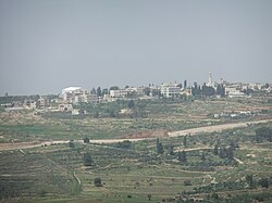
 View of Beit Ijza, 2012 | |
Location of Beit Ijza within Palestine | |
| Coordinates: 31°50′51″N 35°9′9″E / 31.84750°N 35.15250°E | |
| Palestine grid | 164/139 |
| State | State of Palestine |
| Governorate | Jerusalem |
| Government | |
| • Type | Local Development Committee |
| Elevation | 811 m (2,661 ft) |
| Population (2017)[2] | |
• Total | 854 |
| Postcode | P115 [3] |
| Name meaning | Beit Izza, the house of Izza, from personal name [4] |
Beit Ijza (Arabic: بيت إجزا, also spelled Bayt Ijza); is a village in the Jerusalem Governorate in the central West Bank with an area of 2,526 dunams. Located approximately six miles north of Jerusalem, it had a population of 698 in 2007 and 854 by 2017.[2][5]
- ^ Beit Ijza village profile, ARIJ, 2012, p. 4
- ^ a b Preliminary Results of the Population, Housing and Establishments Census, 2017 (PDF). Palestinian Central Bureau of Statistics (PCBS) (Report). State of Palestine. February 2018. pp. 64–82. Retrieved 2023-10-24.
- ^ "وزارة الاتصالات-PostalCodes". Palestine Ministry of Telecom & Information Technology. Archived from the original on 2021-03-06. Retrieved 2022-01-27.
- ^ Palmer, 1881, p. 286
- ^ Population, Housing and Establishment Census 2007. Palestinian Central Bureau of Statistics (PCBS). 2008. Retrieved on 2012-02-27.
