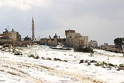
Beitillu | |
|---|---|
| Arabic transcription(s) | |
| • Arabic | بيت إللو |
| • Latin | Beitillu (official) |
 Beitillu | |
Location of Beitillu within Palestine | |
| Coordinates: 31°58′33″N 35°06′54″E / 31.97583°N 35.11500°E | |
| Palestine grid | 161/153 |
| State | State of Palestine |
| Governorate | Ramallah and al-Bireh |
| Government | |
| • Type | Municipality |
| Elevation | 531 m (1,742 ft) |
| Population (2017)[2] | |
| • Total | 3,465 |
| Name meaning | "The house of Ello"[3] |
Beitillu (Arabic: بيت إللو) is a Palestinian town located in the Ramallah and al-Bireh Governorate in the northern West Bank, 19 kilometers Northwest of Ramallah. According to the Palestinian Central Bureau of Statistics, it had a population of 3,465 in 2017.[2]
Presently much of the villagers' traditional land, springs, gardens with olive and fig trees, near the Israeli settlement of Nachliel cannot be accessed, because their way is barred by Israeli soldiers or settlers, often with dogs.[4]
Beitillu, together with Deir 'Ammar and Jammala, form the new town of Al-Ittihad.[1]
- ^ a b Al-Itihad Town Profile (Beitillu, Jammala & Deir 'Ammar), ARIJ, pp. 4-5
- ^ a b Preliminary Results of the Population, Housing and Establishments Census, 2017 (PDF). Palestinian Central Bureau of Statistics (PCBS) (Report). State of Palestine. February 2018. pp. 64–82. Retrieved 2023-10-24.
- ^ Palmer, 1881, p. 226
- ^ Cite error: The named reference
Hasswas invoked but never defined (see the help page).
