This article needs additional citations for verification. (November 2009) |
Bel-Air | |
|---|---|
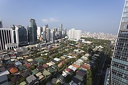
 Bel-Air Village Phase 2 with skyscrapers most of which are also part of the barangay in the background | |
  Location within Makati | |
| Coordinates: 14°33′50.16″N 121°1′34.83″E / 14.5639333°N 121.0263417°E | |
| Country | Philippines |
| Region | National Capital Region |
| City | Makati |
| District | Part of the 1st district of Makati |
| Government | |
| • Type | Barangay |
| • Barangay Captain | Cynthia Cervantes |
| • Barangay Councilors | Members
|
| • SK Chairperson | Christina Alexandra Camus |
| Area | |
| • Land | 1.712 km2 (0.661 sq mi) |
| Population (2020)[1] | |
• Total | 36,007 |
| Time zone | UTC+8 (PST) |
| Postal Code | 1209 (Bel-Air Village) 1227 (Salcedo Village) |
| Area code | 2 |
| PSGC | 137602002 |
Bel-Air refers to both a private subdivision, a gated community and a barangay in Makati, Philippines. To the north the village itself is bound by Kalayaan Avenue, Anza, Orion, Mercedes and Amapola Streets. Estrella Street on the northeast, Epifanio de los Santos Avenue on the southeast, Jupiter Street on the southwest and Nicanor Garcia Street (formerly Reposo) on the northwest. It encompasses a total land area of 171.2 hectares (423 acres) and is shaped roughly like a tobacco pipe.
Bel-Air Village was developed in four phases. The village is managed by the Bel-Air Village Association (BAVA). There are 950 lots, thirty-two streets and two well-developed parks in Phases 2 and 3, each with covered badminton/basketball courts. Makati Avenue separates Phase 2 from the rest of the subdivision.
Aside from Bel-Air Village, the barangay includes Ayala North, Gil Puyat Avenue (Buendia Avenue), the Ayala Triangle and the entire Salcedo Village of the Makati Central Business District.[2]
- ^ Census of Population (2020). "National Capital Region (NCR)". Total Population by Province, City, Municipality and Barangay. Philippine Statistics Authority. Retrieved July 8, 2021.
- ^ "Barangay Bel-Air". Makati Web Portal. Retrieved April 15, 2023.