Bel Aire, Kansas | |
|---|---|
 Location within Sedgwick County and Kansas | |
 | |
| Coordinates: 37°45′50″N 97°15′58″W / 37.76389°N 97.26611°W[1] | |
| Country | United States |
| State | Kansas |
| County | Sedgwick |
| Founded | 1955 |
| Incorporated | 1980 |
| Area | |
• Total | 6.79 sq mi (17.60 km2) |
| • Land | 6.76 sq mi (17.52 km2) |
| • Water | 0.03 sq mi (0.08 km2) |
| Elevation | 1,394 ft (425 m) |
| Population | |
• Total | 8,262 |
| • Density | 1,200/sq mi (470/km2) |
| Time zone | UTC-6 (CST) |
| • Summer (DST) | UTC-5 (CDT) |
| ZIP codes | 67220, 67226 |
| Area code | 316 |
| FIPS code | 20-05400[1] |
| GNIS ID | 473837[1] |
| Website | belaireks.gov |
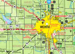
Bel Aire is a city in Sedgwick County, Kansas, United States,[1] and a suburb of Wichita.[5] As of the 2020 census, the population of the city was 8,262.[3][4]
- ^ a b c d e "Bel Aire, Kansas", Geographic Names Information System, United States Geological Survey, United States Department of the Interior
- ^ "2019 U.S. Gazetteer Files". United States Census Bureau. Retrieved July 24, 2020.
- ^ a b "Profile of Bel Aire, Kansas in 2020". United States Census Bureau. Archived from the original on November 14, 2021. Retrieved November 14, 2021.
- ^ a b "QuickFacts; Bel Aire, Kansas; Population, Census, 2020 & 2010". United States Census Bureau. Archived from the original on August 27, 2021. Retrieved August 27, 2021.
- ^ "City of Bel Aire - Our Community". City of Bel Aire. Archived from the original on October 6, 2010. Retrieved January 22, 2011.