Belcourt, North Dakota | |
|---|---|
 Belcourt water tower and Turtle Mountain Middle School | |
 | |
| Coordinates: 48°50′30″N 99°44′41″W / 48.84167°N 99.74472°W | |
| Country | United States |
| State | North Dakota |
| County | Rolette |
| Area | |
• Total | 6.01 sq mi (15.57 km2) |
| • Land | 5.81 sq mi (15.05 km2) |
| • Water | 0.20 sq mi (0.52 km2) |
| Elevation | 1,962 ft (598 m) |
| Population (2020) | |
• Total | 1,510 |
| • Density | 259.90/sq mi (100.34/km2) |
| Time zone | UTC-6 (Central (CST)) |
| • Summer (DST) | UTC-5 (CDT) |
| ZIP code | 58316 |
| Area code | 701 |
| FIPS code | 38-05740[3] |
| GNIS feature ID | 2393335[2] |
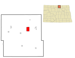
Belcourt is a census-designated place (CDP) in Rolette County, North Dakota, United States. It is within the Turtle Mountain Indian Reservation. The population was 1,510 at the 2020 census.[4]
The community is the seat of the Turtle Mountain Band of Chippewa Indians. Belcourt was originally known as Siipiising, which is Anishinaabe (Chippewa) for "creek that sings with life-giving water." The name refers to what European Americans called "Ox Creek", which flows through the center of town. The town is served by different forms of media, such as KEYA, a tribal radio station that can be found at 88.5 FM; and the Turtle Mountain Times, the tribally owned newspaper that was established in 2003.
- ^ "ArcGIS REST Services Directory". United States Census Bureau. Retrieved September 20, 2022.
- ^ a b U.S. Geological Survey Geographic Names Information System: Belcourt, North Dakota
- ^ "U.S. Census website". United States Census Bureau. Retrieved January 31, 2008.
- ^ "Explore Census Data". Explore Census Data. United States Census Bureau. Retrieved May 24, 2022.

