| Belknap Crater | |
|---|---|
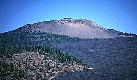
 Belknap shield volcano with lava flows in foreground | |
| Highest point | |
| Elevation | 6,876 ft (2,096 m) NAVD 88[1] |
| Coordinates | 44°17′06″N 121°50′32″W / 44.284943458°N 121.842233094°W[1] |
| Geography | |
| Location | Linn County, Oregon, U.S. |
| Parent range | Cascades |
| Topo map | USGS Mount Washington |
| Geology | |
| Mountain type | Shield volcano |
| Volcanic arc | Cascade Volcanic Arc |
| Last eruption | 480 AD [2] |
Belknap Crater is a shield volcano in the Cascade Range in the U.S. state of Oregon. Located in Linn County, it is associated with lava fields and numerous subfeatures including the Little Belknap and South Belknap volcanic cones. It lies north of McKenzie Pass and forms part of the Mount Washington Wilderness. Belknap is not forested and most of its lava flows are not vegetated, though there is some wildlife in the area around the volcano, as well as a number of tree molds formed by its eruptive activity.
Belknap was named for J. H. Belknap, whose father R. S. Belknap developed Belknap Springs. Early routes through the area extended near Belknap and its lava fields, and in the early 20th century, herds of sheep were moved to the two steptoes that lie among the Little Belknap lava flows to graze. The Oregon Skyline Trail, which runs to the west of Belknap's lava flows, follows paths used by Native American populations, who harvested huckleberries in the area. Today, there are a number of trails that run near Belknap, including ones that extend to Little Belknap and Belknap Crater. Belknap can be seen by tourists at the Dee Wright Observatory, which was built in-part with lava blocks from Belknap Crater.
A precise determination for Belknap's age has not been made, as its early history remains obscure. Belknap has likely been built up by eruptive activity over a long period of time. Belknap Crater has had four Holocene eruptive periods confirmed by geological evidence. In total, the Belknap shield and its multiple vents were formed in less than 1,500 years, its last eruptive episode finishing about 1,500 years ago. Belknap formed on the lower slopes of Mount Washington, a highly eroded volcano, and is one of the larger mafic (rich in magnesium and iron) volcanoes in the Sisters Reach.
Belknap consists of a shield volcano and pyroclastic cone and consists of basaltic and basaltic andesite lava with sub-alkaline composition, and it is characteristic of High Cascade volcanism. Well-preserved, its core is made of cinder materials; its eruptive deposits have well-preserved pressure ridges (tumuli) and levees. There are a number of subfeatures including the Inaccessible Cones, Little Belknap, South Belknap, and Twin Craters, as well as the Belknap hot springs. Postglacial, mafic eruptions are more common in the Sisters Reach — which includes Belknap — than anywhere in the Cascade volcanic arc. However, the Volcano Hazards Program of the United States Geological Survey considers it unlikely that Belknap will erupt again soon.
- ^ a b "Belknap Crater". NGS Data Sheet. National Geodetic Survey, National Oceanic and Atmospheric Administration, United States Department of Commerce. Retrieved May 1, 2019.
- ^ "Belknap". Cascades Volcano Observatory. United States Geological Survey. February 2, 2015. Retrieved May 1, 2019.
