| Belmore Mountain | |
|---|---|
| Sliabh Bhéal Mór | |
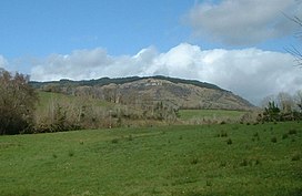
 Belmore Mountain, Spring 2005 | |
| Highest point | |
| Elevation | 398 m (1,306 ft) |
| Prominence | 322 m (1,056 ft) |
| Listing | Marilyn |
| Coordinates | 54°19′26″N 7°47′19″W / 54.3238°N 7.7886°W |
| Naming | |
| English translation | mountain of the big mouth |
| Language of name | Irish |
| Geography | |
| Location | County Fermanagh, Northern Ireland |
| OSI/OSNI grid | H138417 |
| Topo map | OSNI Discoverer 17 |
Belmore Mountain (from Irish Sliabh Bhéal Mór [1], meaning 'big mouth mountain') is a hill in the townland of Gortgall, western County Fermanagh, Northern Ireland. With a summit roughly 398 metres (1,306 ft) above sea level,[2] it is the second highest point in Fermanagh, the highest being at Cuilcagh on the Northern Ireland–Republic of Ireland border in the south of the county. The historian John O Donovan (1834) states that the indigenous population called the mountain Bel Mor Muintir Pheodachain .[3]
Belmore Mountain dominates the skyline in the nearby county town of Enniskillen and gives its name to Belmore Street.
- ^ Placenames Database of Ireland
- ^ Kelly, p. 226
- ^ John O Donovon (1834). "John O'Donovan's letters from County Fermanagh" (PDF). p. 5.
