Belœil | |
|---|---|
| Ville de Beloeil | |
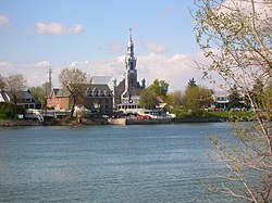
 Downtown Beloeil | |
| Nickname: La Capitale de la Vallée du Richelieu (The Capital of the Richelieu Valley) | |
| Motto(s): Par ta beauté forge demain (By thy beauty shape tomorrow) | |
 Location within La Vallée-du-Richelieu RCM. | |
| Coordinates: 45°34′N 73°12′W / 45.567°N 73.200°W[1] | |
| Country | |
| Province | |
| Region | Montérégie |
| RCM | La Vallée-du-Richelieu |
| Constituted | December 9, 1903 |
| Government | |
| • Mayor | Nadine Viau |
| • Federal riding | Beloeil—Chambly |
| • Prov. riding | Borduas |
| Area | |
• City | 25.50 km2 (9.85 sq mi) |
| • Land | 24.38 km2 (9.41 sq mi) |
| • Urban | 26.50 km2 (10.23 sq mi) |
| Elevation | 14 m (46 ft) |
| Population (2021)[4] | |
• City | 24,104 |
| • Density | 988.8/km2 (2,561/sq mi) |
| • Urban | 52,959 |
| • Urban density | 1,998.5/km2 (5,176/sq mi) |
| • Pop 2016-2021 | |
| • Dwellings | 10,338 |
| Time zone | UTC−5 (EST) |
| • Summer (DST) | UTC−4 (EDT) |
| Postal code(s) | |
| Area codes | 450 and 579 |
| Highways | |
| Website | beloeil |
Beloeil (/bɛˈlaɪl/;[5] French pronunciation: [bɛlœj]) is a city in Quebec, Canada. It is a suburb of Montreal, on the South Shore and is on the Richelieu River, 32 kilometres (20 mi) east of Montreal. According to the official Commission de toponymie du Québec, the name is written Belœil with an oe ligature;[1] however, other sources avoid the ligature, including the Ministry of Municipal Affairs[2] and the town's own official website.[6]
The population as of the Canada 2021 Census was 24,107.[4] It is part of the Regional County Municipality of La Vallée-du-Richelieu, within the Administrative Region of Montérégie. It occupies the west shore of the Richelieu River in front of the Mont Saint-Hilaire. Along with the city of McMasterville to the immediate south of Beloeil, and the cities of Mont-Saint-Hilaire and Otterburn Park on the eastern bank of the Richelieu, Beloeil forms an unbroken urban area of over 52,959 inhabitants,[4] which is part of Greater Montreal.[7][8]
Belœil was created as a village in 1903 and became a ville (city) in 1914, but can trace its history through the parish of Saint-Mathieu-de-Belœil, established in 1772, and the seigneurie de Belœil, founded in 1694. Its name probably derives from the old French expression "Quel bel œil!", meaning "What a beautiful view!", generally attributed to Jean-Baptiste Hertel, brother of the first seigneur (lord) of Belœil, Joseph-François Hertel de la Fresnière.[9][10]
- ^ a b Cite error: The named reference
toponymiewas invoked but never defined (see the help page). - ^ a b c Cite error: The named reference
mamrotwas invoked but never defined (see the help page). - ^ Parliament of Canada Federal Riding History: CHAMBLY--BORDUAS (Quebec)[permanent dead link]
- ^ a b c d "Profile table, Census Profile, 2021 Census of Population - Beloeil, Ville (V) [Census subdivision], Quebec;Beloeil [Population centre], Quebec". 9 February 2022.
- ^ The Canadian Press (2017), The Canadian Press Stylebook (18th ed.), Toronto: The Canadian Press
- ^ Official website
- ^ Beloeil in the Canadian Encyclopedia Archived October 15, 2012, at the Wayback Machine
- ^ Attraits Touristiques, Ville de Beloeil Archived 2012-08-14 at the Wayback Machine, retrieved 2008-12-14
- ^ Lambert, Pierre; Le nom de Belœil a 300 ans!; Société d'histoire de Belœil-Mont-Saint-Hilaire, retrieved on 2012-03-11
- ^ La Petite histoire de la ville de Beloeil, Ville de Beloeil[permanent dead link], retrieved 2012-03-11

