Bend | |
|---|---|
 A photograph of the Sacramento River as it passes through Bend, California. | |
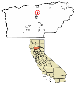
 Location of Bend in Tehama County, California. | |
| Coordinates: 40°15′19″N 122°12′31″W / 40.25528°N 122.20861°W | |
| Country | |
| State | |
| County | Tehama |
| Area | |
| • Total | 3.17 sq mi (8.21 km2) |
| • Land | 2.91 sq mi (7.55 km2) |
| • Water | 0.26 sq mi (0.66 km2) 8.07% |
| Elevation | 335 ft (102 m) |
| Population (2020) | |
| • Total | 603 |
| • Density | 206.93/sq mi (79.89/km2) |
| Time zone | UTC-8 (Pacific (PST)) |
| • Summer (DST) | UTC-7 (PDT) |
| ZIP code | 96080 |
| Area code | 530 |
| GNIS feature IDs | 1658034 |
| U.S. Geological Survey Geographic Names Information System: Bend, California | |
Bend is a census-designated place in Tehama County, California, United States. Bend is located on the Sacramento River 6 miles (9.7 km) north-northeast of Red Bluff. Bend had a post office from 1897 to 1935. The community was originally known as Horsethief Bend; the name was changed to Sander's Bend and later shortened to Bend.[3] The community was named after a nearby meander in the Sacramento River.[4] The population was 619 at the 2010 census.

- ^ "2020 U.S. Gazetteer Files". United States Census Bureau. Retrieved October 30, 2021.
- ^ U.S. Geological Survey Geographic Names Information System: Bend, California
- ^ Durham, David L. (1998). California's Geographic Names: A Gazetteer of Historic and Modern Names of the State. Clovis, Calif.: Word Dancer Press. p. 193. ISBN 1-884995-14-4.
- ^ "Place Names" (PDF). Archived from the original (PDF) on May 8, 2017. Retrieved March 25, 2018.
